Cattle Management Maps:
the step-by-step visual farm plan
Cattle farming happens in three-dimensions, out on pasture, so it is extremely helpful to be able to visualize, on a map, your cattle management strategies for every part of your cattle business.
The easiest way to design your management strategy is to plan every part of your business on separate transparent map overlays that you can lay over your farm base map.
Creating layered farm maps will help guide every step of your business - from the construction of your electric fence infrastructure and livestock water system, to the day-to-day grazing strategies that you will use in both summer and winter, and right through to how you will manage your pasture rotation during calving, grass-finishing, weaning, and cattle breeding.
The more planning you do in advance, on paper, the easier it becomes to respond to the constantly changing variables that are part of this weather and livestock-dependent business. The maps you draw in your farm plan are key to your success in the grass-fed beef industry.
Creating simple map layers
Plan your infrastructure in stages using multiple transparent overlays, such as velum, tracing paper, or onion paper. Lay these transparencies over your clean simple farm map so you can show or hide individual parts of your plan as you need them. Do not draw directly on the farm map.
Using photo-editing software instead of hand-drawn maps
(Disclosure: I get commissions for purchases made using Amazon links in my post.)
|
If you are computer savvy, use a drawing software program that allows you to draw in "layers" similar to overlaying transparencies on a physical map. My personal favorite is Adobe Photoshop Elements#CommissionsEarned, which is a simple, intuitive, and inexpensive photo-editing software program with a complete set of drawing tools. (It's the user-friendly and inexpensive little brother to the much more expensive Adobe Photoshop Creative Suite used by photography professionals. |
The individually editable layers make it very simple and easy to modify your farm plan at any time as your grazing tactics and cattle management strategies evolve, without having to redraw new maps from scratch. Every part of your cattle management plan can get its own dedicated layer - you can create as many layers as you want.
Start by creating a base layer - simplified topographic and geographic info only
Start your farm plan by creating a base map as a transparent layer overlaid on an air photo or scaled topographic map of your farm. This becomes your background layer or base layer. (Using a map that is to scale is extremely important for your grazing management and makes it very simple to order materials, like wire, posts, or pipe for your cattle water system, simply by measuring the distances on your farm map.
On your base layer, trace the outline of your farm and add topographic and geographic features like rivers, ponds, forests, roads, corral locations, swamps, etc. This base layer allows you to see important features during planning while allowing you to hide the visual clutter of your air photo simply by temporarily 'hiding' the air photo underneath.
How to get free air photos of your farm
|
Computer users can place an image of their air photo underneath their base map by setting their air photo as their background layer, with the base layer being Layer 1 (you can rename layers at any time). You can find free air photos of your farm using Google Maps; just click on the "Satellite" icon in the upper right-hand corner of Google Maps to switch from regular map to air photo view. If you download Google's free Google Earth Plug-In, you can even tilt your maps to see your topographic features in 3-D, as though flying over your farm in an airplane. |
To capture screenshots of these maps and transfer them to your computer use the Snipping Tool, provided free on most Windows operating systems, or download one of the many free screen capture programs available on the web, such as PicPick or Screenpresso or my favorite open-source screen capture tool Greenshot.
Create individual layers for each component of your cattle management plan
Create additional transparent map layers for each individual component of your farm plan, such as for your electric fence infrastructure, water lines, winter grazing rotations, instructions for calving on pasture, etc.
Planning in layers allows you to plan each component of your cattle management plan separately, without overwhelming your map with everything at once. Simply overlay whichever transparencies are relevant to you at any given time and remove the rest.
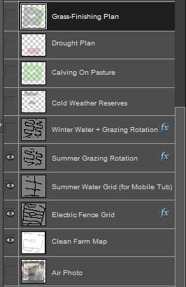
Adobe Photoshop Elements allows you to show or hide individual layers simply by clicking the eyeball in the box next to each individual layer, as shown in the screen grab on the right. For example, during the winter you can hide your summer water infrastructure and summer grazing rotation simply by choosing to hide those layers. Your calving season grazing strategy can be hidden until you need it just in time for calving or you can temporarily show or hide your underlying air photo as you need it. Each individual layer can be refined and re-edited as your grazing strategy evolves from year to year.
Example farm plan, in layers...
Follow the link to see a simple example of an actual farm plan that uses this layered approach to individually address each component of the year-round cattle management plan.
Dealing with Existing Cattle Fences
Do not draw existing cattle fencing into your farm base map. During your planning process you want to view the farm as if it's a clean slate to be able to design the most efficient and most flexible cattle management strategy.
Existing fences distort your view and tie you into a previous cattle management strategy that may or may not be the best fit for your grass-fed beef production goals. Once the planning process is complete, existing fences that line up can be kept, the rest can be torn down.
The single-wire electric fences used for the corridors of your electric fence grid are so cheap and easy to build that there simply is no reason to hang onto existing cattle fencing that doesn't fit your program. Follow the link to learn more tips about how to deal with existing cattle fences in your cattle management plan.
Related Articles:
(Disclosure: I get commissions for purchases made using Amazon links in my post.) And when you're ready to start planning your cattle farm, check out my book: Grass-Fed Cattle: How to Produce and Market Natural Beef. Use the links below to explore my book and read reviews on Amazon: 
|

